
Aerial Solutions to your projects
Save time and expenses with aerial solution.
About Our Drone Services
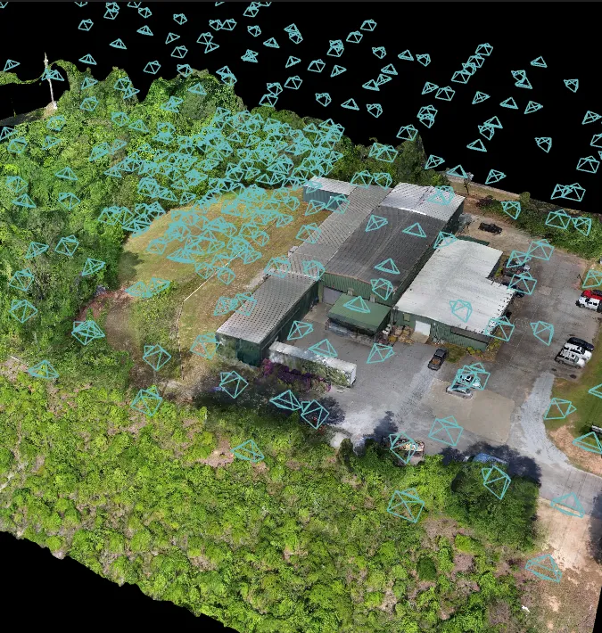
Heyer Drone Services delivers professional aerial intelligence and specialized educational support. Leveraging the power of Drone Deploy, we execute precision 3D Modeling and critical infrastructure Inspections, transforming complex data into actionable digital twins.
Our environmental services include multispectral Vegetation Analysis for advanced crop and land management. Distinctly, our Academic Consulting division empowers educators in grades 5-12. We utilize the Drone Legends curriculum to implement immersive STEM programs, guiding schools through the adoption of drone technology to inspire the next generation of innovators.
Our Drone Services
Seeing the world from a different perspective

Construction Monitoring
We specialize in creating custom patio designs tailored to your unique style and preferences. Our team works closely with you to envision and bring to life the perfect outdoor living space that suits your needs.

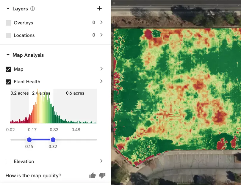
Vegetation Analysis
Drones equipped with multispectral or standard RGB cameras capture high-resolution aerial imagery, which Drone Deploy transforms into actionable plant health insights. utilizing algorithms like NDVI (Normalized Difference Vegetation Index) and VARI (Visible Atmospherically Resistant Index), the platform processes this data to visualize crop stress, vigor, and density. This analysis enables precise vegetation management, allowing users to identify pest issues, irrigation deficiencies, and nutrient needs with centimeter-level accuracy for data-driven agricultural decision-making.
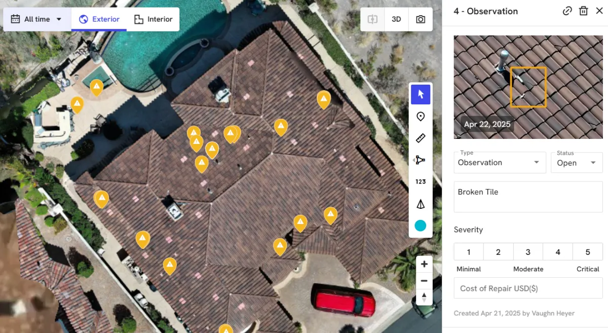
Aerial Inspection and Reporting
Drone Deploy dramatically streamlines the inspection workflow for Heyer Drone Services. After capturing high-resolution drone imagery, the platform enables precise annotation of defects, damage, or points of interest directly onto 2D maps and 3D models. Users can define custom Field Notes with severity levels, status, and cost estimates. Crucially, Drone Deploy automatically compiles these annotations, source photos, and location data into standardized, shareable PDF inspection reports. This centralizes visual documentation, accelerates issue tracking, and allows Heyer to efficiently communicate findings and necessary repairs to clients and stakeholders.
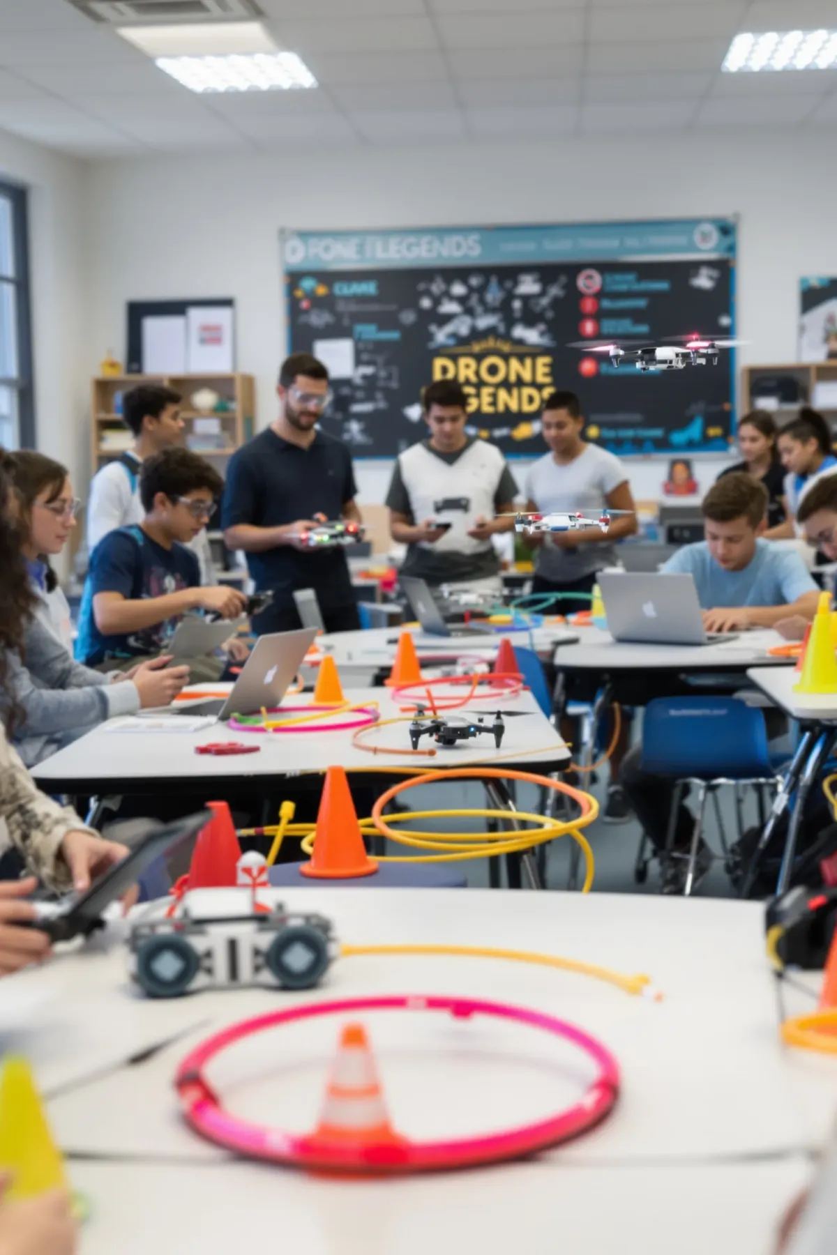
Scholastic Consulting
Heyer Drone Services collaborates with local schools to implement the Drone Legends STEM curriculum. The program builds foundational STEM Fundamentals through engaging, drone focused STEM missions. At the high school level, this culminates in the FPV Initiator program. Students master advanced drone mechanics and repair while gaining hands-on experience with competitive racing drones and First-Person View (FPV) flight. This rigorous training prepares young innovators for future technical careers.
See What Our Customer Say About Us


John Doe

Lorem ipsum dolor sit amet, consectetur adipiscing elit, sed do eiusmod tempor incididunt ut labore et dolore magna aliqua. Ut enim ad minim veniam.

John Doe
Lorem ipsum dolor sit amet, consectetur adipiscing elit, sed do eiusmod tempor incididunt ut labore et dolore magna aliqua. Ut enim ad minim veniam.

John Doe
Lorem ipsum dolor sit amet, consectetur adipiscing elit, sed do eiusmod tempor incididunt ut labore et dolore magna aliqua. Ut enim ad minim veniam.
Frequently Asked Questions
What Drones do you fly?
We have a plethora of drones from US made Skydio to high quality cinematic drones made by DJI and Construction monitoring drones made by Autel
Do you need a license to fly a drone for anything other than recreation?
Yes, and being paid is not a determining factor. The FAA states that any activity other than recreational falls under the Part 107 laws. And if you use or hire someone who doesn't have their FAA part 107 certification, you could be held liable.
Does Heyer Drone Solutions have insurance?
Yes, we maintain both drone and general liability insurance and can name your or your company as Co-Insured if needed at no extra cost.
Are there areas where drone are restriced from flying in Southern Nevada?
Southern Nevada contains significant FAA restricted flight areas due to the concentration of major airports and sensitive government airspace (Classes B, C, D, and Special Use Airspace). This makes commercial drone operations complex. However, as an FAA Part 107 Licensed Drone Service Provider, Heyer Drone Services is authorized to request and receive official clearance through systems like LAANC. This ensures legal access to fly in controlled airspace, delivering necessary aerial data that unlicensed operators cannot legally obtain.
Isn't it too expensive to hire a licensed and insured Drone Service Provider?
Maybe not, fill out our contact form to see how we can be creative to provide services at a price that works for you.
Do you handle permits?
This depends on the project, but we have obtained permits from the City of Las Vegas, Clark Couty and the City of Henderson